跳转到主要内容
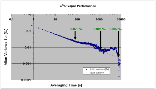
  • 百万分比,无与伦比?Picarro 推出新型水同位素分析仪,其精度可达百万分比

    When I joined Picarro at the start of September in 2009, Cavity Ring-Down Spectroscopy technology for isotope analysis had only just been created. In short order CRDS was validated by researchers whose laboratories specialized in using isotope ratio mass spectrometers (IRMS), devices which were previously considered the state of the art.

  • 屋顶花园、通量、热岛和水质:LDEO NYC 项目对绿色屋顶的影响

    In a week when heat waves are sweeping the country, a post about green roofs seems appropriate. Environmentalists have long espoused putting plants on top of buildings as a way to improve air quality in cities and reduce the urban island heat effect. Sounds nice, but what are the real impacts of green roofs? Will they reduce runoff water into storm drains? Will they clean the runoff water? Will they cool the city? And will green roofs absorb or emit methane and other greenhouse gases.

  • ,

    实地笔记:Picarro 访问北格陵兰岛Eemian冰芯钻探营地(NEEM)

    As I write this, I’m sitting on a ski-equipped LC-130 Hercules cargo plane from the New York Air National Guard’s 109th Airlift Wing, flying over Greenland, having just taken off from the NEEM camp at 77°N latitude where the sun is up 24 hours a day.

  • 翼下吊舱、无人机与 NASA = 酷炫新科学

    I've got two simple yet evocative phrases  for you. Wing pods. Unmanned Aerial Vehicles. Excited? We are. During late June, a team of top scientists from the NASA Ames Research Center deployed three Picarro analyzers as part of the The Railroad Valley Vicarious Calibration Campaign, a collaboration between the Japan Aerospace Exploration Agency (JAXA), and NASA's Jet Propulsion Laboratory (JPL), Pasadena, Calif. One of the analyzers was deployed in a wing pod of an Alpha jet which flew up to altitudes of 25,000 feet. Another was deployed in the nose cone of an Unmanned Aerial Vehicle.

  • 对流层污染测量仪测得一氧化碳地表混合比率(按体积算十亿分之一)

    什么是气候“模型”,它从何而来?

    Climate scientists can be divided into two large interactive groups: Experimentalists, who go out into the world and collect climate data (e.g., levels of carbon dioxide, methane concentration, seasonal temperature, snowfall rates, etc.); and Modelers, those who build computer simulations based on that data (called “climate models” by those in the know) to estimate how climate variables affect one another (e.g., does increasing CO2 increase temperature enough to melt polar ice caps that will raise sea levels so high that Miami will be the next Atlantis?).